

Imagine being in the middle of a vast ocean or a dense desert with nothing but a small device in your hand. Within seconds, that device tells you exactly where you are, down to a few meters. This feat, which we now take for granted, is a marvel of modern physics and engineering. While most
Imagine being in the middle of a vast ocean or a dense desert with nothing but a small device in your hand. Within seconds, that device tells you exactly where you are, down to a few meters. This feat, which we now take for granted, is a marvel of modern physics and engineering. While most people use it to find the nearest coffee shop, the Global Positioning System (GPS) underpins critical global infrastructure.
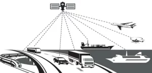
From synchronizing power grids to guiding autonomous vehicles, accurate positioning is the invisible backbone of the modern world. But how does a signal from space translate into such precise data on Earth?
This article explores the sophisticated mechanisms behind GPS accuracy, from atomic clocks to error correction. We will also examine how this technology drives major industrial developments, specifically looking at its transformative impact on Airport engineering , a sector where precision is not just a goal—it is a necessity.
Understanding the Basics: What Is GPS Navigation?
To appreciate how accuracy is achieved, we must first answer the fundamental question: what is GPS navigation? At its core, GPS is a satellite-based radio navigation system owned by the United States government and operated by the United States Space Force. It provides geolocation and time information to a GPS receiver anywhere on or near the Earth where there is an unobstructed line of sight to four or more GPS satellites.
While it started as a military project in the 1970s, it has evolved into a global utility. The system relies on a constellation of approximately 30 satellites orbiting about 20,000 kilometers above us. These satellites act as precise reference points. By knowing the exact position of these satellites and the distance to them, a receiver can calculate its own position. However, the difference between knowing you are “in a city” versus “standing on a specific street corner” relies on complex science and rigorous error correction.
The Science Behind the Precision
The accuracy of GPS is not accidental; it is the result of extreme engineering precision. The system relies on measuring the time it takes for a signal to travel from a satellite to a receiver. Since radio signals travel at the speed of light, even a microsecond error in timing can result in a position error of 300 meters.
The Role of Atomic Clocks
The heart of GPS accuracy lies in timekeeping. Each GPS satellite carries multiple atomic clocks. These are not like the quartz watch on your wrist; they use the oscillations of atoms (usually cesium or rubidium) to keep time with incredible stability. They drift by less than one second every 300,000 years.
Your phone or car receiver, however, uses a standard quartz clock, which is far less accurate. To solve this mismatch, the GPS system requires a signal from a fourth satellite. This fourth signal allows the receiver to calculate the time deviation of its own internal clock compared to the satellite’s atomic time, mathematically correcting the error and ensuring precise distance measurement.
Solving the Geometry with Trilateration
While many people confuse it with triangulation (which uses angles), GPS actually uses trilateration. This geometric principle involves measuring distances to pinpoint a location.
- One Satellite: If you know you are 20,000 km from Satellite A, you could be anywhere on a sphere with that radius.
- Two Satellites: If you are also 19,000 km from Satellite B, your location is narrowed down to the circle where the two spheres intersect.
- Three Satellites: Adding a third distance measurement narrows your position to just two points. One is usually far out in space or deep within the Earth, leaving only one logical location on the surface.
Overcoming Obstacles: Signal Processing and Error Correction
Ideally, radio signals would travel through a vacuum directly to your receiver. In reality, they pass through the Earth’s atmosphere, bounce off buildings, and encounter various interferences. High-accuracy GPS depends on sophisticated signal processing to mitigate these errors.
Atmosphere and Ionosphere Delays
As satellite signals enter the Earth’s atmosphere, they pass through the ionosphere—a layer filled with charged particles. These particles can slow down or bend the radio signals, creating a delay that the receiver might misinterpret as a longer distance. Modern GPS receivers use complex algorithms to model and correct for these atmospheric delays. Dual-frequency receivers are even more effective, as they compare two different signal frequencies to physically measure the delay occurring in the ionosphere.
Multipath Errors
In urban environments with tall skyscrapers, “canyons” of concrete and glass can confuse GPS systems. A signal might bounce off a building before reaching your phone. This increases the travel time of the signal, tricking the receiver into thinking the satellite is further away than it actually is. This phenomenon is known as the multipath error. Advanced signal processing techniques and specialized antenna designs help receivers distinguish between the direct signal and the reflected “echoes.”
Augmentation Systems
For industries that require centimeter-level accuracy, standard GPS isn’t enough. They rely on augmentation systems like SBAS (Satellite-Based Augmentation Systems). These systems use ground stations at known locations to monitor satellite signals. If a ground station detects an error in the satellite’s data, it transmits a correction message to users in that region. This is how aircraft can land automatically and how surveyors can map land with extreme precision.
Case Study: Precision in Airport Engineering Qatar
Nowhere is the demand for precision higher than in aviation infrastructure. A prime example of high-level application is Airport engineering. As Qatar has positioned itself as a major global transit hub connecting East and West, the engineering behind its aviation facilities, particularly Hamad International Airport (HIA), relies heavily on advanced GPS technologies.
The engineering challenges in this region are unique. Developing massive infrastructure in a desert climate on reclaimed land requires rigorous planning and monitoring. Here is how GPS systems drive accuracy in this specific sector.
Construction and Infrastructure Layout
When constructing an airport that spans over 22 square kilometers, traditional surveying methods are too slow and prone to human error. In the context of Airport engineering Qatar, construction teams utilize Real-Time Kinematic (RTK) GPS.
RTK involves a fixed base station and mobile rovers. The base station sends real-time corrections to the rovers used by surveyors and construction machinery. This allows for:
- Precise Grading: Runways must be perfectly flat and sloped exactly for drainage. GPS-guided graders ensure the ground is leveled to within millimeters of the architectural plans.
- Asset Placement: The exact placement of runway lights, navigational aids, and taxiway signage is critical for safety. GPS ensures these elements are installed exactly where the digital blueprints specify.
Enhancing Air Traffic Management
The engineering of an airport extends beyond concrete and steel; it includes the design of the airspace itself. Qatar has implemented advanced Performance-Based Navigation (PBN) procedures.
PBN relies on the integrity and accuracy of GPS signals rather than ground-based radio beacons. This allows aircraft to fly more direct, precise paths. For Airport engineering Qatar, this means designing approach and departure routes that maximize airspace capacity while minimizing noise and fuel consumption. The reliability of the GPS signal allows for “curved” approaches that keep aircraft away from residential areas until the last moment, a feat impossible with older technology.
Operational Efficiency on the Ground
Once built, the engineering focus shifts to maintenance and operations. High-precision GPS is embedded into the operational fabric of Qatar’s airports.
- Resource Tracking: In the searing heat of the region, efficiency is vital. GPS telematics track baggage carts, fuel trucks, and shuttle buses. Engineers analyze this movement data to redesign road layouts and optimize traffic flow within the airfield.
- Pavement Monitoring: Engineers use GPS-equipped sensors to monitor the settling of reclaimed land. By tracking the precise vertical position of the runway over time, they can predict maintenance needs before cracks appear, ensuring continuous operation of the hub.
The Future of Global Positioning
We are entering a new era of positioning technology. The latest generation of GPS satellites (GPS III) creates signals that are three times more accurate and up to eight times more powerful than previous generations.
Furthermore, GPS is no longer alone. It is now part of a “System of Systems” called GNSS (Global Navigation Satellite System), which includes Europe’s Galileo, Russia’s GLONASS, and China’s BeiDou. Modern receivers can track satellites from all these constellations simultaneously. This multi-constellation approach dramatically improves accuracy and reliability, especially in challenging environments like deep urban canyons or mountainous regions.
Conclusion
From the atomic clocks ticking in orbit to the smartphone in your pocket, the journey of a GPS signal is a testament to human ingenuity. It is a complex dance of physics, mathematics, and engineering that occurs at the speed of light.
Understanding what is GPS navigation opens our eyes to the invisible threads connecting our world. It is not just about finding a route to the grocery store; it is about the technology that enables massive container ships to dock safely, farmers to harvest crops with robotic precision, and nations to build world-class infrastructure.
As seen in the advancements within Airport engineering Qatar, the pursuit of greater accuracy is reshaping industries. As these systems become even more precise, we can expect further innovations in autonomous transportation, smart cities, and global logistics, proving that knowing exactly where you are is the first step to going somewhere new.